Charlotte Metro agencies prepare for possible weekend winter storm bringing ice, sleet, outages and travel hazards
Forecast points to mixed winter precipitation and heightened risk of ice-related damage
Preparations are underway across the Charlotte metro as forecasts indicate a winter storm could bring a prolonged mix of rain, sleet and freezing rain, with temperatures dropping to levels that support ice accumulation and hazardous travel. The strongest signal in the forecast is the potential for significant icing, a scenario that can down trees and power lines and create extended road hazards even after precipitation ends.
The seven-day outlook for Charlotte shows a transition from milder midweek conditions into colder air late week. Rain and drizzle are expected Friday, followed by a shift toward sleet and freezing rain over the weekend, with temperatures near or below freezing. Continued cold afterward would increase the likelihood that ice remains on untreated surfaces into early next week.
Road treatment focuses on pre-storm anti-icing and priority corridors
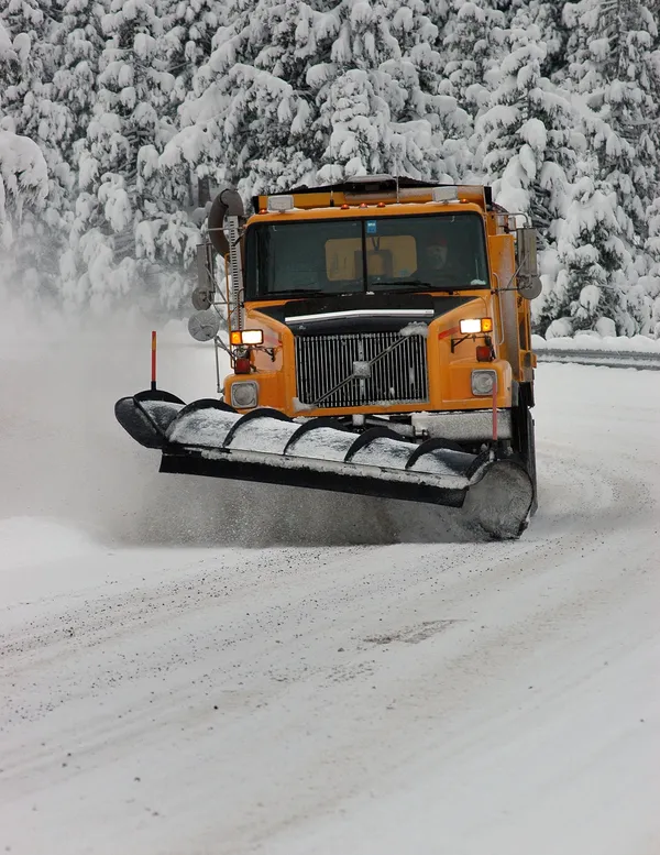
Transportation planning typically centers on preventing ice from bonding to pavement, which is most effective when applied ahead of precipitation. In recent winter events, road crews in Charlotte have pre-treated major routes and emergency-access corridors with salt brine, a salt-and-water solution designed to reduce initial ice formation. Priority is generally given to interstates, primary arterials and routes serving hospitals and other critical facilities, with secondary streets treated as conditions and staffing allow.
- Pre-treating key corridors to limit early ice bonding
- Focusing first on high-volume routes and emergency-access roads
- Monitoring temperature trends that determine whether treatments remain effective
Utilities stage crews and warn of outage risk from ice-laden trees and lines
Electric utilities serving the region routinely scale storm response as icing potential rises. Crew staging is designed to shorten restoration times after conditions become safe, but heavy ice can slow damage assessment and repairs by blocking roads and creating hazardous working conditions.
Utilities have emphasized that ice buildup on trees and branches is a primary driver of outages in winter storms, with accumulation levels around a quarter-inch often sufficient to trigger limb failures. Higher ice totals can also weigh directly on lines, increasing the risk of sagging or line damage.
EMS and airport operations adjust for safety, access and continuity
Public safety agencies typically anticipate increased demand during winter weather, including crashes, falls and medical calls complicated by slower travel times. Ambulance crews have previously equipped vehicles with de-icing supplies and tools intended to improve patient access and reduce on-scene delays when surfaces are slick.
At Charlotte Douglas International Airport, winter operations commonly include aircraft de-icing and the use of specialized snow-removal and de-icing vehicles to keep taxiways and ramp areas operational. Even when the airport remains open, ice events can still disrupt schedules, as airlines adjust to aircraft de-icing needs, ramp safety limits and regional air-traffic constraints.
Residents are typically urged to finalize supplies and plans before conditions deteriorate, since ice can rapidly make roads impassable and slow emergency response.
What to watch next
The most consequential details—how quickly temperatures fall, how long precipitation overlaps with subfreezing air, and whether freezing rain dominates—will determine whether the weekend brings mainly slushy travel issues or more severe ice impacts. Updates to winter weather advisories and any changes in the temperature profile over the metro will be central to refining expected road conditions and outage risk.