Morning Freeze and Afternoon Thaw: Charlotte Navigates Post-Blizzard Hazards
A Bitter Start After the Historic Blizzard
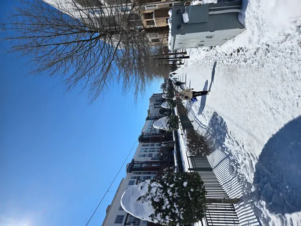
Charlotte residents are waking up to a dangerously cold morning this Tuesday, February 3, 2026, as the region continues to grapple with the aftermath of last weekend’s historic snowstorm. With a record-breaking 11.4 inches of snow recorded at Charlotte/Douglas International Airport, the primary concern for the morning commute is the prevalence of black ice. Temperatures early this morning have dipped as low as 19°F to 24°F, causing any melting snow from previous days to re-freeze into treacherous, invisible sheets of ice on area roadways and sidewalks.
Morning Forecast: Sub-Freezing Conditions
Through the mid-morning hours, temperatures will struggle to climb, remaining well below the freezing mark. Wind chills are expected to make the air feel like it is in the single digits in some outlying areas. Due to these hazardous conditions, Charlotte-Mecklenburg Schools (CMS) and many surrounding districts have announced full closures for today. Additionally, Mecklenburg County offices have delayed their opening until noon to allow city crews more time to treat primary corridors. Residents are urged to avoid travel if possible; if you must drive, exercise extreme caution on bridges, overpasses, and shaded secondary roads where ice persists.
Afternoon Outlook: A Brief Thaw
By the afternoon, a shift in weather patterns will bring some relief. Forecasters predict a high of approximately 44°F to 47°F under partly sunny skies. While these temperatures are still slightly below the seasonal average, they will be sufficient to trigger significant melting of the heavy snowpack. Winds will remain relatively calm, shifting from a northerly direction to the south-southwest by late afternoon. This brief period of sunshine will be the best window for residents to clear remaining slush from driveways and walkways before temperatures drop again tonight.
Evening and Overnight: Rain and Refreezing Risks
As we transition into the evening, cloud cover will increase significantly across the Queen City. Temperatures will hold relatively steady compared to previous nights, with an expected low near 37°F. However, the National Weather Service warns of a 40% chance of precipitation moving into the area after midnight. While most of this will manifest as light rain or patchy fog, there remains a slight risk of a wintry mix in the early hours of Wednesday morning if temperatures drop faster than anticipated. The combination of melting snow runoff and overnight moisture means that refreezing will remain a major threat through tomorrow morning.
Safety Summary and Notices
- Travel: High risk of black ice through 10:00 AM. Many secondary roads remain impassable or narrowed by snow banks.
- Closures: All CMS activities are canceled. County services begin at 12:00 PM.
- Infrastructure: Watch for falling ice from buildings and trees as the afternoon thaw begins.
- Preparedness: Ensure pets are kept indoors and check on neighbors, particularly the elderly, who may be snowed in.