NCDOT outlines Sunday winter storm response and road conditions for Charlotte-area counties into next week
Charlotte-region crews shift from preparation to response as ice coats roads
Transportation leaders in North Carolina used a Sunday morning briefing in Charlotte to describe how road crews are responding to a winter storm that brought sleet to the region overnight and was expected to transition into freezing rain through the day. The update focused on five counties covered by the local transportation division: Anson, Cabarrus, Mecklenburg, Stanly and Union.
By early Sunday, many roads across the Charlotte area were already slick as sleet accumulated on pavement. Forecasters warned that freezing rain could add a glaze of ice, elevating the risk of crashes and making some routes difficult or impossible to travel. State and local officials reiterated that travel should be limited to essential trips while crews work to treat and clear roads.
State emergency posture expanded ahead of the storm
North Carolina entered the weekend with an elevated emergency posture. A statewide state of emergency was declared several days before the storm’s arrival, and state response coordination was activated to support communities as conditions changed. Emergency officials also highlighted the likelihood that winter weather impacts could extend beyond the initial onset, with hazardous travel and potential utility disruptions lasting into Monday.
What transportation officials emphasized: treatment priorities and shifting conditions
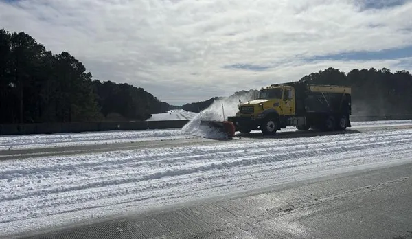
Road treatment and clearing operations typically prioritize routes with the highest traffic volumes and regional importance, starting with interstates and then moving to U.S. and N.C. highways, followed by secondary roads. Ice events can complicate that work because freezing rain can quickly recoat treated surfaces, and continued precipitation can outpace crews’ ability to keep every roadway passable.
In the Charlotte-area briefing, transportation officials outlined three main operational focus areas:
storm response activities while sleet and freezing rain continue;
monitoring road conditions and crash hotspots as temperatures remain below freezing;
preparations for continued impacts into the start of the workweek.
Guidance for drivers: reduce risk and plan for limited mobility
Officials urged residents to assume untreated surfaces could be icy, including bridges, overpasses and shaded roadways where temperatures can remain lower. For those who must travel, transportation and emergency managers advised building extra time into trips, maintaining larger following distances and avoiding sudden braking or sharp steering inputs.
Residents were also advised to prepare for possible interruptions to normal routines, including delays in public services and challenges reaching destinations as conditions evolve.
Looking ahead: impacts expected to linger into Monday
Weather alerts across North Carolina were expected to remain in effect through midday Monday, with wintry precipitation and freezing conditions extending the period of travel risk. Transportation leaders said the public’s cooperation—staying off roads where possible—helps crews concentrate resources on priority routes and emergency access while the storm cycle continues.
For the Charlotte region, the message from Sunday’s storm briefing was consistent: conditions can deteriorate quickly during freezing rain, and the safest option remains postponing non-essential travel until temperatures rise and road conditions stabilize.