Severe storms with large hail could impact Charlotte, Upstate South Carolina, and nearby mountain communities
What is expected
Weather forecasters are tracking a setup that could bring severe thunderstorms to the Charlotte region, the Upstate of South Carolina, and nearby mountain areas, with large hail among the primary hazards. The threat is not uniform across the region; severe storms typically form in clusters or lines, and impacts can vary sharply over short distances depending on where the strongest cells develop.
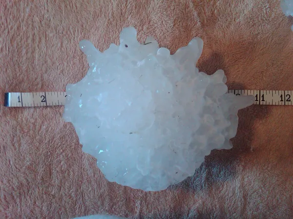
The highest-impact storms in this type of pattern can produce hail large enough to damage vehicles, roofing and siding, along with bursts of damaging wind capable of downing trees and power lines. Frequent cloud-to-ground lightning and sudden reductions in visibility in heavy rain are also common in severe thunderstorm events.
Where the risks are concentrated
The corridor spanning the Charlotte metro into the South Carolina Upstate is routinely vulnerable when stronger storms move east from the mountains and foothills into the Piedmont. In addition, mountain and foothill communities can experience rapid storm intensification as stronger winds aloft interact with local terrain, sometimes producing the earliest rounds of storms before activity shifts east.
Large hail is most often tied to thunderstorms with strong updrafts that can keep hailstones suspended long enough to grow before falling. When those storms organize into longer-lived structures, the risk of repeated impacts—hail, wind, and lightning—can increase within the same communities over a short period.
Timing and how warnings may change
Severe-weather forecasts are frequently refined on the day of the event as forecasters get updated data on instability, wind shear, and storm initiation. Residents should be prepared for outlooks to change and for watches or warnings to be issued with limited lead time once storms begin to organize.
In severe-weather setups, the practical difference between “possible” and “likely” often depends on whether storms can develop early enough to take advantage of peak daytime heating and stronger winds higher in the atmosphere.
What to do ahead of storms
Have multiple ways to receive warnings, including wireless emergency alerts and a weather radio if available.
Plan for hail and wind: move vehicles under cover when time allows and secure lightweight outdoor items.
If a warning is issued, go indoors and stay away from windows; hail and wind-driven debris can shatter glass.
Prepare for localized power outages by charging devices and keeping flashlights ready.
What to watch for as storms approach
Key signs of a strengthening storm include rapidly darkening skies, a sudden increase in wind, and frequent lightning. Hail can begin with little notice, especially along the leading edge of a storm line. For mountain communities, rapid changes can occur with limited visibility and faster-developing cells; drivers should avoid flooded roadways and reduce speed in heavy rain.
As the threat evolves, the most actionable information will come from real-time watches and warnings issued for specific counties and neighborhoods.